
Prince Edward Street (County Road 64 ) Reconstruction
Northumberland County, in partnership with the Municipality of Brighton, is undertaking a multi-year reconstruction of Prince Edward Street (County Road 64). Reconstruction of Prince Edward Street will strengthen Brighton’s core infrastructure, enhance safety and accessibility, and support long-term community growth. County Road 64 is a vital corridor for the Municipality of Brighton, providing a key north-south link through the community and a connection to Prince Edward County. Several segments of the road and underground infrastructure have reached the end of their service life and are no longer meeting the needs of residents, businesses, and visitors.
This project is a major investment in the future of the region — supporting safe travel, efficient transportation, and long-term economic growth.
2024 – Rural Section
In 2024, the County completed resurfacing and shoulder work on the rural stretch of County Road 64 between Harbour Street and Stoney Point Road. This work included culvert replacement, the addition of paved shoulders and the installation of a turtle nest.
2025 – Urban Section south of Loyalist
In 2025, the County completed reconstruction of the urban section between Harbour Street and Loyalist Rd, including sewar and watermain repairs, sidewalks and cycling paths, road grading and paving and some traffic calming features.
Current Project Phase: Urban Section (2026)
Beginning in early spring 2026, construction on the urban section of Prince Edward Street between Harbour Street and Elizabeth Street. Work will include:
- Replacement of aging watermains and sewers
- Road resurfacing and grading improvements
- New sidewalks and paved cycling lanes or multi-use paths
- Intersection and safety improvements
- Pedestrian crossovers for improved safety
- Road resurfacing and grading improvements
What to Expect
Work will be carried out in stages to limit disruption, with updates provided regularly. This section of road will be fully closed to through traffic during active construction, with detours clearly marked. Local access will be maintained where possible.
- Temporary road closures and detours
- Noise and dust during active construction hours (7 a.m. to 7 p.m.)
- Changes to access for driveways, sidewalks, and public transit routes
- Efforts to maintain emergency access and minimize disruptions
Work will take place in coordinated phases to improve efficiency and minimize overall disruption, with updates provided regularly.
Construction for the 2026 season is expected to continue through the fall, with overall project completion anticipated by October 30, 2026.
Phase 1: Harbour Street to Loyalist Drive
- Start: Early April
- Installation of temporary water beginning late April
- Servicing work to begin early May (or sooner)
- work coordinated alongside Phase 3
- Completion: end of July
Phase 3: CN/CP Rail Crossing to Elizabeth Street
- Start: Early April
- Installation of temporary water beginning late April
- Work coordinated alongside Phase 1
- Completion: end of October
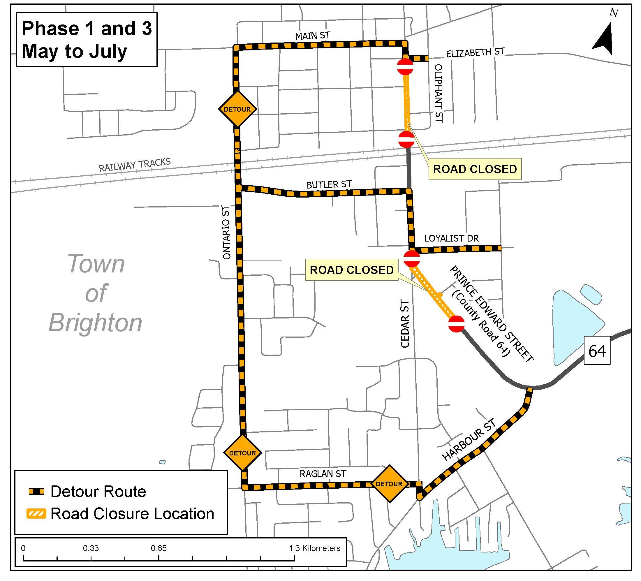
Phase 2: Loyalist Drive to CN/CP Rail Crossing
- Start: early August (following Phase 1 completion)
- Installation of temporary water beginning late April
- Servicing work beginning early August
- Work coordinated alongside Phase 3
- Completion: end of October
Phase 3: CN/CP Rail Crossing to Elizabeth Street
- Start: Early April
- Installation of temporary water beginning late April
- Servicing work beginning early May
- Work coordinated alongside Phase 2
- Completion: end of October

Additional Works
- CN/CP rail crossing work: June 8 – June 19 (may be adjusted based on construction progress)
- Harbour Street (south limits): Late July – early August
This reconstruction will modernize critical infrastructure, improve safety for all users, and support Brighton’s continued growth by creating a more connected, accessible, and resilient transportation corridor.
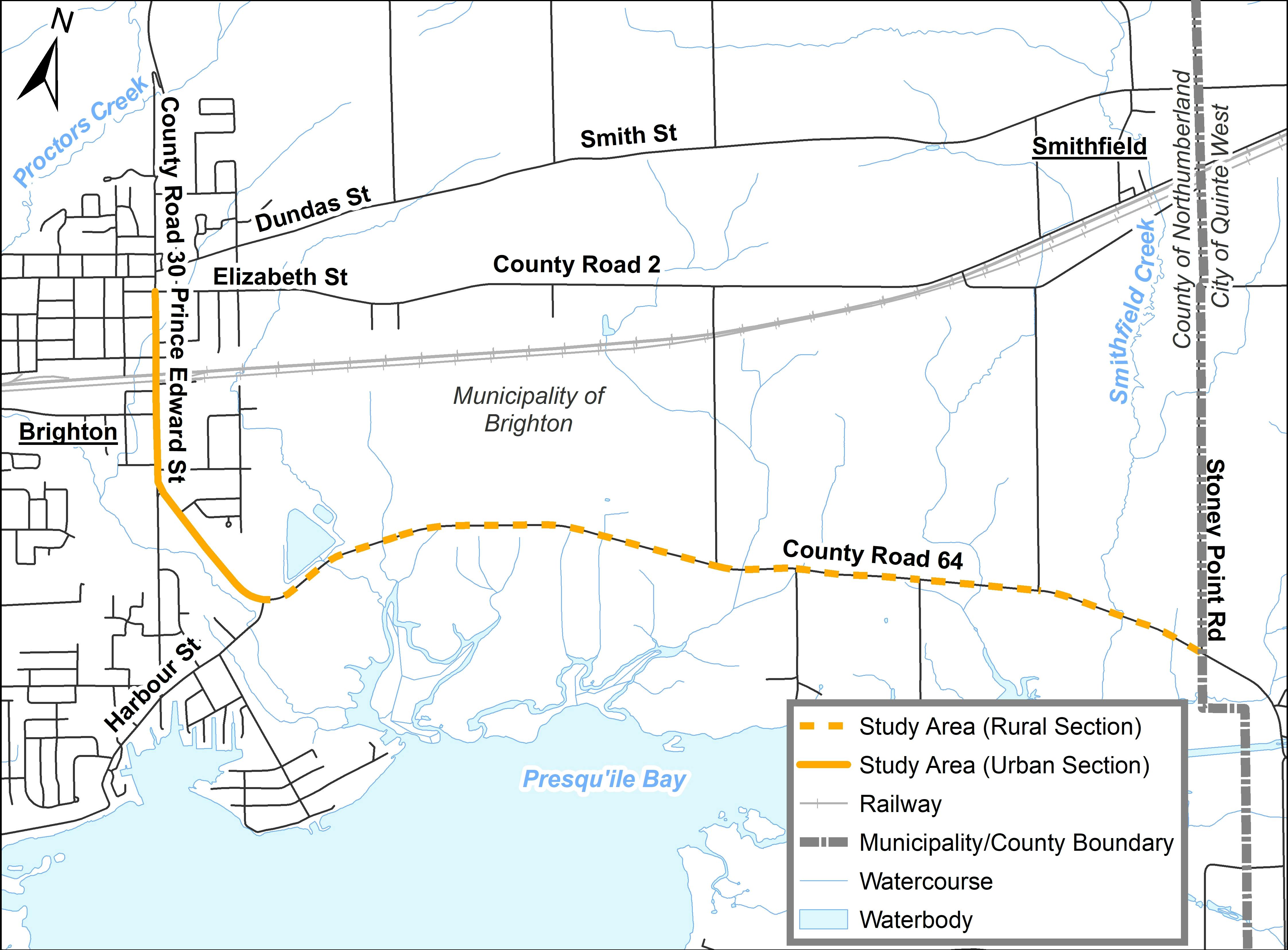
The study
The County undertook a study, following Schedule ‘B’ of the Municipal Class Environmental Assessment process, with broad community input, to develop a design plan for County Road 64 (Prince Edward Street) to address the existing infrastructure needs as well as support the travel and mobility needs of the community. The study covered 6.9 kilometres of road, extending from Elizabeth Street in downtown Brighton to the Quinte West boundary at Stoney Point Road. The study is divided into two sections:
2024 Rural road section: Harbour Street to Stoney Point Road
2025/26 Urban road section: Elizabeth Street to Harbour Street
Second public information session: Completed March 21, 2023
On Tuesday, March 21 from 5 pm to 7 pm, an in-person public information session was held at the King Edward Park Arena, in Brighton. Information and preferred designs where presented on infrastructure and intersection upgrades, as well as suggestions on how best to improve sidewalks, traffic calming features and multi-use features for cyclists and pedestrians.
- View the presentation slides in the document tab.
First public information session: Completed July 27, 2022
On Wednesday, July 27, 2022, Northumberland County and representatives from the Municipality of Brighton held the first of two public information sessions to review the opportunities for improvement.
Meeting materials
- View the presentation slides in the documents tab.
- View the video recording of the presentation.
Join in the conversation
- Sign up for our email distribution list for updates about the project and opportunities to provide your feedback. Click ‘subscribe’ under the ‘Stay Informed’ box.
- Email the project team to submit private questions.
- Share your feedback with the project team and other Join In Northumberland participants by submitting a response to the public comment box below.


Nice to see the rural part of hwy#64 completed. Looks great and it’s a nice smooth ride!
Now on to Prince Edward Street construction ….we live off of Harbour Street, having moved here a few years ago. The amount of traffic on Harbour has been quite surprising. Because of this, the traffic going from and to Prince Edward to Harbour makes for a very busy intersection!
A roundabout/traffic circle would be perfect for this location.
I am just wondering while the construction is going on and opening the roads on #64, will you also be working to put bell fibre lines in as well to increase the internet in Brighton?
Nice to see a bike lane included - and it should link to paved shoulders west of town as well as one going down Ontario st to presquile . Bike lanes calm traffic and direct visitors to local businesses. Look at how many vehicles are going to the provincial park with bikes attached.
Someone on Facebook posted a thread about Turtle signs being put cause of turtles being kills on that road , why don't Brighton put a up Protective turtle fencing along the road way to keep the turtle safe that way it works great in Kingston, When I used to live in Kingston years ago there was no fencing type put up and when we drove that road we ended up seeing died turtles and we had signs up there on both side of the road, and most of the time that didn't work that is why Kingston put up a Protective turtle fencing.
Have you considered a traffic circle for Prince Edward and Harbour intersection? Many people treat stop sign as a yield, especially during morning commute times. The circle would serve as speed calming measure and make the intersection safer all around. I think there is enough space to build a small circle.
Hopefully with the infrastructure construction additional catch basins could be added to extend from the present to Harbour Street so that consideration could be given to backfilling the ditches which would help in grass trimming work.
I'm not sure how wide a shared walk/bicycle path would be but if it resembles the paved sidewalk on the south side of Prince Edward Street we might find cars parking on it as they presently do. Mothers with carriages have to walk around on the road to get by. There has been one parked in front of #190 for over a week now.
Of the traffic calming ideas, I think the automated speed radar display would be a help. We've noticed some placed in the Cramahe area on roads far less travelled. The very best, however, would be a recording radar camera so speeders could be issued tickets. On observing the regular traffic on Prince Edward, such a unit would pay for itself in a very short time.
I think a sidewalk would be a benefit on the north side of Prince Edward St. as the present one ends abruptly at Stephen St. It would benefit those living on that side of the street as we see them cross over to the south side when walking
The meeting was quite interesting and I'd like to comment on some of the points. Infrastructure definitely needs upgrades after witnessing a water main break on Prince Edward St. a year ago last October
I prefer Option 2, which keeps bicyclists off the road surface. The roadway is not that wide, and with the volume of large vehicle traffic it supports, more mishaps seem certain with Option 1.
I also agree with the concerns noted below about more traffic diverting to Boes Rd, which would certainly result in the need for a more formalized management of the two-way flow under the train bridge ie stop lights. Even with the sparse traffic now, I see southbound drivers race through to avoid a momentary yield, causing some close calls.
As others have commented, I feel its important to separate bicyclists, scooters etc from vehicle traffic within the proposed upgrades. Especially in view of the increasing heavy truck traffic. I like the Concept 2, sidewalk and multi-use path. I'd like to see a heavy truck alternate route somehow designed in to this plan, to divert trucks going to the Loyalist Industrial Park, away from Prince Edward/64. I'd like to see some permanent improvements to the steep change in grade, and hardscaping at the double railroad tracks to replace the field of weeds currently there. Finally, I'd like to see the current weird "triangle intersection" where Cedar and 64 meet, possibly replaced with a roundabout.
I am most concerned about improvements to pedestrian and cycling infrastructure. In particular, I feel that separating bicycles from vehicle traffic is important to do, wherever possible, to improve safety and encourage cycling. For the urban portion, I like Concept 2, sidewalk + multi-use path. Because pedestrians and cyclists would need to cross the road just south or north of the railway, as shown in the presentation, it will be critically important that safe crossing infrastructure be established at the crossing point, such as the pedestrian crossover described in the presentation.
I also support the use of traffic calming measures, particularly at the gateway between the urban and rural portions. Speed radar signs, on-road markings, narrowing the roadway, and gateway signage all seem like useful options to slow traffic while not impeding access by emergency vehicles.
Thank you for the comprehensive presentation last night. I encourage options for walking and bike lanes (especially MUP) that enhance attractiveness and the environment. Does the path have to be paved, for example? Or could it be the hard-packed surface used on rail trails? Is there any room for the trail to be further distanced from the road (notably on the rural portion), or to at least meander a bit in some sections? Can green space be enhanced at all? For calming: gateway signs such as the yellow/30 example, surrounded by flowers, invites rather than demands. One electronic sign as at the approach to the urban section helps me as a driver, but only at a transition point, and only once.
Thanks.
After attending last nights meeting there is another concern. If traffic is calmed along 64, people will use Bose Rd as an alternative and tragic will increase there. People already use this route to avoid the train tracks and speeding is a real issue. As the bridge only allows one car at a time and is an honour system for cars to get through I see a potential for accidents to increase. While Bose Rd is a municipal road this needs to be taken into consideration.
Something not mentioned last night was police presence and radar. This is huge deterrent. Once it’s understood that tickets are involved people will get the message “you don’t want to speed in Brighton” In my last township a patrol car parked at the side of the road was enough to slow people down.
Is there any consideration for improvement of the level crossing on Prince Edward?
Would like to know what calming features are being considered?
Speeding is an issue on Prince Edward Street. The town could see a windfall in fines if speed cameras were installed. It would be like shooting fish in a bucket. Most local residents (not all) do obey the speed limit. Drivers of tandem dump trucks should be paid by the hour not the load.
I anticipate major water main reconstruction after a water main break on Prince Edward Street a year ago last October.
Hopefully with infrastructure improvement, additional catch basins could be added to existing ones to further the storm drain capacity. It is hoped that those ditches beyond the present basins could then be levelled.